
Atmospheric Turbulence: The Jet Stream
In 1926, meteorologist Wasaburo Oishi discovered some high speed airflows over Japan. Since he was the head of the Japanese Esperanto Institute, he decided to publish his findings in Esperanto language as well, under the name of “Raporto de Aerologia Observatorio de Tateno”. Understandably, his work had minimal diffusion.
During World War II, pilots began to notice strong winds that scattered their bombs when dropping them over Europe. Such reports were initially disregarded, but then, similar observations were done by B-29 pilots while bombing Japan. This led to an investigation that finally presented (in English) the jet streams to the scientific community. Sadly, the jet stream owes its discovery to such pitiful activities.
What is the jet stream?
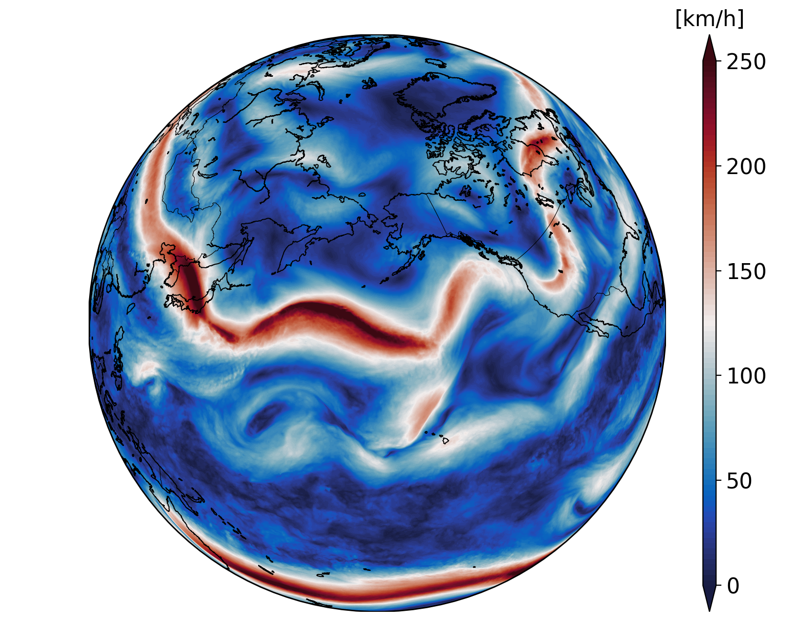
Jet streams are narrow bands of high velocity air flowing at about 250 km/h (135 kts) and located between 9-16 km (30,000-52,000 ft).
The polar jet, located at about 60o in latitude, tends to be stronger than the subtropical jet, located at about 30o. Both of them flow from east to west and follow a meandering pattern. Their high speeds and velocity changes can lead to strong turbulence in flights, and is therefore is one of the most important meteorological parameters in aviation.
Jet streams are triggered by two main parameters: the equator to poles temperature gradient and the Coriolis force. The meandering pattern is known as Rossby Waves, triggered by the conservation of vorticity.
Let's look at each of these factors more in detail.
Earth's circulation cells
The Earth's climate is not a chaotic motion of air masses. The uneven warming of the Earth (higher on the equator than on the poles), generates a series of circulation cells which, despite their seasonal and geographical variability, induce a relatively stable air circulation pattern.
The first one of these circulation loops is known as the Hadley cell. The loop starts in the equator, with steam and hot air raising due to the intense solar radiation, which in turn creates the rainforest climate. The hot air spreads fast towards the poles without forming clouds or rain, leading to deserts, and finally slows down and falls in the form of rain to create the temperate climate. Part of this air returns to the equator, closing the circulation loop. Some of it continues to the next cells.
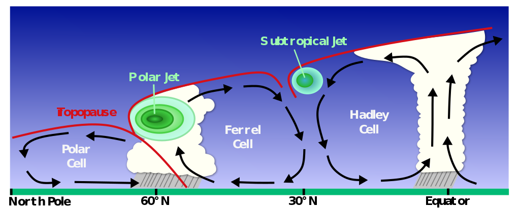
The Polar cell is generated by part of the hot air released from the equator, which cools down until reaching the geographic poles. Contrary to the Hadley cell, which has the shape of a belt around the Earth, the Polar one is like a casket on top the north and southern hemispheres.
The Ferrel cell sits in between the Hadley and the Polar cells, acting like a gearbox between the two, and inducing the climate we are used to in part of Europe and North America.
The description above is clearly simplified, and the specific geography of each continent can lead to large differences to the extent of the cells. This is due to the blockages caused by mountain ranges and to the different solar reflection from land and sea masses.
The Coriolis force
With the different circulation cells in place, jet streams are triggered the Earth's rotational force, known as Coriolis force.
The physics of this force are relatively simple. The equator has a larger diameter than the polar circles, so it spins faster than these. As a result, any air mass flowing northwards will carry a higher eastwards speed, deflecting its trajectory towards the east in a clockwise manner. In the southern hemisphere, the air is also deflected towards the east, leading to an anti-clockwise rotation. This is also why hurricanes spin in different directions in the north and southern hemispheres.
So, when the rising flow of the Hadley cell is flowing north or south from the equator, it's slowly deflected eastwards by the Coriolis force, and at some point it's completely parallel to the Equator, forming a belt of high speed air: the subtropical jet stream.
In the Ferrel cell, the air flowing towards the Polar cell is also deflected by the Coriolis force to form the polar jet stream. This jet tends to follow a more wavy pattern than the subtropical one due to its larger tendency to generate of Rossby Waves. Therefore, the polar jet is also known as the eddy-driven jet.
Rossby Waves
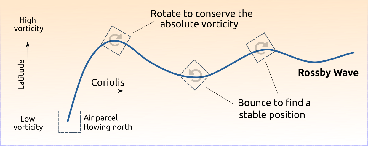
Weather satellites and computational analysis shows that the jet streams move in a meandering pattern. What causes such behavior?
To understand this need to use the concept of vorticity, which is a measure the rotation in a fluid. As all the Earth rotates at the same speed, all points have the same planetary vorticity. However, vorticity is a vector, and it's the vertical component, the one perpendicular to the Earth's surface, the one that is the main driver for atmospheric flows. This component becomes zero at the equator, and maximum at the poles.
As a result, air parcels traveling north see an increase in the vertical planetary vorticity. The equations of fluid mechanics require the absolute vorticity (sum of the planetary and parcel vorticity) to be conserved. Therefore, the air parcel tries to conserve its original low vorticity by spinning and generating negative vorticity, causing it to bounce down. After this, the air parcel follows a wavy pattern in which the forces trying to allocate it a stable position compete with the spinning forces required for vorticity conservation. This is a Rossby-Wave.
The waves are also affected by topography and differences in temperature with altitude as the air parcel moves (baroclinicity). Both of these parameters induce the same net effect: squeeze the air parcel, forcing it to stretch and spin faster, inducing a change in its trajectory.
The combination of all these parameters lead to what is known as Baroclinic Rossby Waves. Since the vertical planetary vorticity is largest at the poles, the polar jet stream is much more affected by these than the subtropical one.
Jet steams are very fast, but their Rossby Wave pattern is much slower, taking about 6 days for a set of these waves to go around the Earth. Their size is also large, with a half-wavelength in the order of 5000 km.
How strong is the turbulence inside a jet stream?
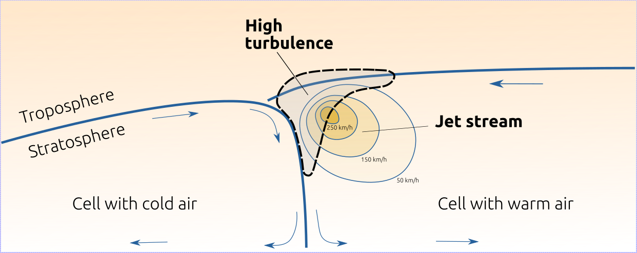
Turbulence is mainly generated in regions with high velocity differences. If we take a stream of fast flowing air, all of it traveling at the same speed, the turbulence generated by it will be on the light side. However, if the flow of air has a very fast centerline, and slow speed on the sides, then we can expect heavy turbulence in the region between the high and low speeds.
This is what happens in a jet stream. It's core usually has light turbulence, but it's edges can be packed with strong one. The sides of the jet which present the highest velocity gradients are at the top, towards the troposphere, and beside it's neighboring circulation cell.
Research done using high resolution measurements from balloons has shown that the turbulence in the troposphere fold (the top of the jet stream) can reach severe levels which are about 1,000 times larger than the turbulence below. Aircraft measurements also confirm this findings, such as the severe and moderate turbulence levels observed while flying over the troposphere fold of the Antarctic Peninsula.
Winter also tends to produce stronger and more turbulent jet streams. This is due to the large temperature difference between the equator and poles than during the summer.
Forecasting jet streams
In our previous articles on mountain waves and cumulonimbus clouds, we highlighted the difficulty to capture such small-scale features in the weather models and to accurately predict their turbulence. Jet streams have the advantage that they are very large, so they can be well captured with the 13 km resolution used in the GFS forecast from NOAA.
Another advantage is that jet streams are not only critical for flights. They also shape the Earth's climate by keeping hot or cold weather within their circulation cells. As a result, weather models are carefully calibrated to predict the pattern of the jets accurately. All the high and low pressure regions that we see in a weather briefing are caused by the meanders of the jet stream. Cold spells are also caused when a Rossby Wave of the polar jet reaches lower latitudes.
Traveling along a jet stream
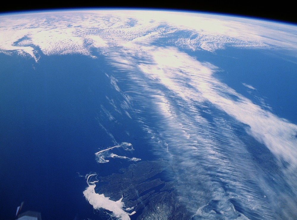
An advantage of jet streams is that, if a plane takes a ride along one of them, their flight time can be significantly reduced. In 2020, British Airways flight from New-York to London hit a record by arriving 1 h and 15 min ahead of schedule thanks to the boost provided by the jet stream. There is of course a risk of entering the high turbulent areas of the jet, but pilots will tend to minimize these chances by following the latest forecasts and in-aircraft measurements.
In fact, flight between Europe and America tend to be planned to make the best use of the jet stream. Since the jet flows towards the east, flights bond to Europe are usually located at higher latitudes, where the jet stream is, whereas flights bond to America are directed below it to avoid having a strong headwind which could cause delays.
Nevertheless, this flight planning is becoming more and more difficult due to the recent changes in the polar jet stream, which for the past years shows a much larger variability of its meandering pattern. Although more research is needed, this behavior has been attributed to global warming.
References
John M. Lewis, 2003. Oishi's observation. Viewed in the Context of Jet Stream Discovery. American Meteorological Society.
Naiman Z., et al., 2017. Impact of Mountains on Tropical Circulation in Two Earth System Models. Journal of Climate, 30(11), 4149-4163.
Willem Jan van de Berg. (Potential) Vorticity, the swirling motion of geophysical fluids . University of Utrecht course.
Alan Plumb R. Rossby Waves and planetary scale motions. MIT course, Atmospheric and Ocean Circulations.
Söder J., et al., 2021. High-Resolution Observations of Turbulence Distributions Across Tropopause Folds. Journal of Geophysical Research: Atmospheres, 126(6), .
Rodrigez Imazio P., et al., 2022. Clear Air Turbulence Observed Across a Tropopause Fold Over the Drake Passage—A Case Study. Journal of Geophysical Research: Atmospheres, 127(4).
Lee S., Kim H.K., 2003. The Dynamical Relationship between Subtropical and Eddy-Driven Jets. Journal of Climate, 60(12), 1490-1503.

